
Ficheiro:Civilizations map.png

Ficheiro orixinal (1.427 × 634 píxeles; tamaño do ficheiro: 41 kB; tipo MIME: image/png)
| Este ficheiro procede de Wikimedia Commons. A continuación móstrase a información da súa páxina de descrición. Commons é un repositorio libre de ficheiros multimedia. Pode contribuír alí cargando as súas imaxes. |
Resumo
| Descrición |
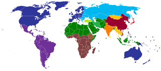
English: A map of civilizations, loosely based (see below) on Huntington's 1996 "Clash of Civilizations" (p. 26).
The NINE "civilizations" identified by Huntington are:
Other colors should indicate (light green, turquoise) the cultural fault lines where the clash of civilizations will occur. There are nine blocks shown in the original 1996 map. The additional colors, including the "fault line" countries in light green or turquoise are due to the judgement of the uploaders/creators of this map, not to Huntington. Other differences from the original map:
Español: Un mapa de civilizaciones, basado libremente (ver abajo) en el "Choque de civilizaciones" de Huntington en 1996 (p.26).
Las NUEVE "civilizaciones" identificadas por Huntington son:
Otros colores deben indicar (verde claro, turquesa) las fallas culturales donde ocurriera el choque de civilizaciones. Hay nueve bloques que se muestran en el mapa original de 1996. Los colores adicionales, incluidos los países de la "línea de falla" en color verde claro o turquesa, se deben a la opinión de los usuarios/creadores de este mapa, no a Huntington. Otras diferencias del mapa original:
Русский: Карта этнокультурного разделения цивилизаций, построенная по концепции Хантингтона.
עברית: תשע ה"ציביליזציות" שזוהו על ידי הנטינגטון הן:
Suomi: Tähän tulee suomenkielinen teksti. A map of civilizations, loosely based (see below) on Huntington's 1996 "Clash of Civilizations" (p. 26).
The NINE "civilizations" identified by Huntington are:
|
| Data | |
| Orixe | Obra propia (Usergreatpower) |
| Autoría | Usergreatpower em Wikipedia em inglés |
| Outras versións | File:Clash of Civilizations map.png |
Licenza
| O autor desta obra, Usergreatpower em Wikipedia em inglés, liberouna e agora pertence ao dominio público. Isto é válido en todo o mundo. Nalgúns países, isto pode non ser legalmente posible; entón: Usergreatpower concede a calquera o dereito de empregar esta obra para o propósito que considere oportuno, sen condicións, agás aquelas que sexan requiridas pola lei. |
Rexistro de cargas orixinal
- 2008-11-20 23:07 Usergreatpower 1427×742× (55694 bytes) {{Information |Description=Clash of Civilisations map |Source=I created this work entirely by myself. |Date=20/11/2008 |Author=~~~ |other_versions= }}
| Anotacións | Esta imaxe ten anotacións: Olle as anotacións en Commons |
Historial do ficheiro
Prema nunha data/hora para ver o ficheiro tal e como estaba nese momento.
| Data/Hora | Miniatura | Dimensións | Usuario | Comentario | |
|---|---|---|---|---|---|
| actual | 16 de maio de 2020 ás 19:49 | | 1.427 × 634 (41 kB) | Babelia | According to the book, Argentina is Latin American (despite the white majority and the southern European cultural influence) |
| 27 de marzo de 2019 ás 04:01 |  | 1.427 × 634 (37 kB) | Enterlousy | Since this is based LOOSELY on "Clash of Civilizations" I made some adjustments. As in the book, Mindanao is Islamic. However, Argentina should be Western, due to heavy Italian, German, and French influence due to immigration. | |
| 25 de xullo de 2013 ás 08:03 |  | 1.427 × 634 (38 kB) | Nikola Štuban | Croatia was in darker blue than the rest of the western world | |
| 19 de xullo de 2013 ás 19:39 |  | 1.427 × 634 (38 kB) | Quite vivid blur | Updated map to include South Sudan, corrections according to Samuel P. Huntington's The Clash of Civilizations. | |
| 9 de maio de 2013 ás 10:27 |  | 1.427 × 634 (50 kB) | Valentinian | Rv one edit. Huntington very expressly assigns Turkey to its own category. | |
| 8 de marzo de 2013 ás 10:40 |  | 1.427 × 634 (50 kB) | Maphobbyist | Adjusted the green color for Turkey to the same hue used for Muslim countries. | |
| 14 de febreiro de 2013 ás 00:36 |  | 1.427 × 634 (50 kB) | Yerevanci | since when is Turkey an Orthodox state? | |
| 12 de novembro de 2012 ás 19:58 |  | 1.427 × 742 (54 kB) | Wester | map is based on a book | |
| 16 de setembro de 2012 ás 11:09 |  | 1.427 × 742 (62 kB) | 23prootie~commonswiki | South Sudan is African. | |
| 31 de xullo de 2012 ás 22:02 |  | 1.427 × 742 (35 kB) | Carnby | Added South Sudan border since this map is based on present day political world map; probably it would have been better to choose a map with the borders of Huntington's times |
Uso do ficheiro
A seguinte páxina usa este ficheiro:
Uso global do ficheiro
Os seguintes wikis empregan esta imaxe:
- Uso en ar.wikipedia.org
- Uso en be-tarask.wikipedia.org
- Uso en be.wikipedia.org
- Uso en br.wikipedia.org
- Uso en ca.wikipedia.org
- Uso en ckb.wikipedia.org
- Uso en en.wikipedia.org
- Talk:Persecution of Christians in the post–Cold War era/Archive 1
- Talk:Roman Empire/Archive 7
- Wikipedia:Graphics Lab/Map workshop/Archive/Jun 2012
- User:The Stray Dog
- User talk:Robert McClenon/Archive 13
- User:The Stray Dog/COC
- User talk:Tryptofish/Archive 31
- User talk:KDTW Flyer/Archive 2016
- User:Oshwah/TalkPageArchives/2019-01
- User talk:CAPTAIN RAJU/Archive 68
- Uso en eo.wikipedia.org
- Uso en es.wikipedia.org
- Uso en fa.wikipedia.org
- Uso en fi.wikipedia.org
- Uso en fr.wikipedia.org
- Uso en he.wikipedia.org
- Uso en incubator.wikimedia.org
- Uso en ml.wikipedia.org
- Uso en nl.wikipedia.org
- Uso en pl.wikipedia.org
- Uso en pms.wikipedia.org
- Uso en pt.wikipedia.org
- Uso en ru.wikipedia.org
- Uso en tg.wikipedia.org
- Uso en uz.wikipedia.org