
Ficheiro:Hungary map ES.png
Tamaño desta vista previa: 800 × 577 píxeles. Outras resolucións: 320 × 231 píxeles | 640 × 462 píxeles | 1.023 × 738 píxeles.
Ficheiro orixinal (1.023 × 738 píxeles; tamaño do ficheiro: 69 kB; tipo MIME: image/png)
| Este ficheiro procede de Wikimedia Commons. A continuación móstrase a información da súa páxina de descrición. Commons é un repositorio libre de ficheiros multimedia. Pode contribuír alí cargando as súas imaxes. |
| Descrición |
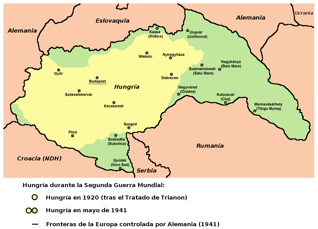
English: Hungary in 1920 and in 1941.
Español: Hungría en entreguerras, cambios territoriales, adaptado del mapa del usuario Panonian. |
| Data | (UTC) |
| Orixe | |
| Autoría |
|
References
- The Times History of Europe, Times Books, London, 2002.
- Richard Overy, The Times History of the 20th Century, Times Books, London, 2004.
- Peter Rokai - Zoltan Đere - Tibor Pal - Aleksandar Kasaš, Istorija Mađara, Beograd, 2002.
- http://terkepek.adatbank.transindex.ro/kepek/netre/224.gif
- http://www.hunmagyar.org/tor/terkep.jpg
- http://www.map.hu/galeria/orig/1426_hu_in_maps_fig_12_states_1648-2009.jpg archive copy at the Wayback Machine
| Esta é unha imaxe retocada,en o que significa que a súa versión orixinal foi alterada dixitalmente. Modificacións: Spanish version. Countries and legend in Spanish. A orixinal pódese ver aquí: Hungary map.png. As modificacións realizounas Rowanwindwhistler.
|
Licenza
| O autor desta obra, Rowanwindwhistler, liberouna e agora pertence ao dominio público. Isto é válido en todo o mundo. Nalgúns países, isto pode non ser legalmente posible; entón: |
Rexistro de cargas orixinal
This image is a derivative work of the following images:
- File:Hungary_map.png licensed with PD-user
- 2009-12-16T19:28:22Z PANONIAN 1023x738 (70714 Bytes) Reverted to version as of 19:23, 16 December 2009 - fixing thumbnail problem
- 2009-12-16T19:26:17Z PANONIAN 800x540 (15951 Bytes) Reverted to version as of 23:57, 23 December 2006 - fixing thumbnail problem
- 2009-12-16T19:23:07Z PANONIAN 1023x738 (70714 Bytes) improved version
- 2006-12-23T23:57:30Z Electionworld 800x540 (15951 Bytes) {{ew|en|PANONIAN}} == Licensing == {{PD-user|PANONIAN}} [[Category:Maps of the history of Hungary]] [[Category:Maps of the history of Romania]]
Carregada com derivativeFX
Historial do ficheiro
Prema nunha data/hora para ver o ficheiro tal e como estaba nese momento.
| Data/Hora | Miniatura | Dimensións | Usuario | Comentario | |
|---|---|---|---|---|---|
| actual | 1 de xaneiro de 2010 ás 10:53 | | 1.023 × 738 (69 kB) | Rowanwindwhistler | {{Information |Description={{en|1=Hungary in 1920 and in 1941. * The Times History of Europe, Times Books, London, 2002. * Richard Overy, The Times History of the 20th Century, Times Books, London, 2004. * Peter Rokai - Zoltan Đere - Tibor Pal - Aleksa |
Uso do ficheiro
A seguinte páxina usa este ficheiro: