
Ficheiro:Faroe islands map with island names.png

Tamaño desta vista previa: 450 × 600 píxeles. Outras resolucións: 180 × 240 píxeles | 600 × 800 píxeles.
Ficheiro orixinal (600 × 800 píxeles; tamaño do ficheiro: 29 kB; tipo MIME: image/png)
| Este ficheiro procede de Wikimedia Commons. A continuación móstrase a información da súa páxina de descrición. Commons é un repositorio libre de ficheiros multimedia. Pode contribuír alí cargando as súas imaxes. |
Resumo
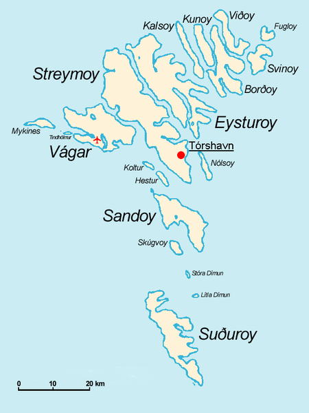
Español: Mapa de las Islas Feroe. Posición del aeropuerto marcado con el avión rojo.
- The Faroe Islands
- Graphics Arne List
- Description: This basic map shows the names of the 18 islands plus the islet Tindhólmur west of Vágar, which is not counted as one of the islands. Furthermore, on this map you see the Airport Vágar and the capital Tórshavn, the two international destinations, if you come via plane or ferry. Last but not least bears the sea no caption, for this map should be translated in different languages by yourself. The sea in the West is the North Atlantic Ocean, and in the East Norwegian Sea (which is a part of the Atlantic).

|
Autorízase a copia, distribución e/ou modificación deste documento baixo os termos da licenza de documentación libre GNU, versión 1.2 ou calquera outra que posteriormente publique a Free Software Foundation; sen seccións invariables, textos de portada, nin textos de contraportada. Inclúese unha copia da devandita licenza na sección titulada GNU Free Documentation License. |
| Este ficheiro está licenciado baixo a licenza Creative Commons recoñecemento compartir igual 3.0 sen adaptar. | ||
| ||
| A etiqueta desta licenza engadiuse a este ficheiro como parte da actualización da licenza GFDL. |
derivative works
Obras derivadas deste ficheiro: Faroe islands map with island names-2.JPG
Historial do ficheiro
Prema nunha data/hora para ver o ficheiro tal e como estaba nese momento.
| Data/Hora | Miniatura | Dimensións | Usuario | Comentario | |
|---|---|---|---|---|---|
| actual | 18 de novembro de 2004 ás 09:32 | | 600 × 800 (29 kB) | Arne List | GFDL |
Uso do ficheiro
A seguinte páxina usa este ficheiro:
Uso global do ficheiro
Os seguintes wikis empregan esta imaxe:
- Uso en azb.wikipedia.org
- Uso en be.wikipedia.org
- Uso en ca.wikipedia.org
- Uso en cs.wikipedia.org
- Uso en da.wikipedia.org
- Uso en de.wikipedia.org
- Uso en ee.wikipedia.org
- Uso en eo.wikipedia.org
- Uso en eu.wikipedia.org
- Uso en ext.wikipedia.org
- Uso en fo.wikipedia.org
- Uso en fr.wikipedia.org
- Uso en fr.wiktionary.org
- Uso en ga.wikipedia.org
- Uso en hu.wikipedia.org
- Uso en id.wikipedia.org
- Uso en is.wikipedia.org
- Uso en mr.wikipedia.org
- Uso en nl.wikipedia.org
- Uso en nn.wikipedia.org
- Uso en no.wikipedia.org
- Uso en os.wikipedia.org
- Uso en pl.wikipedia.org
- Uso en pt.wikipedia.org
- Uso en ru.wikipedia.org
- Uso en sh.wikipedia.org
- Uso en sr.wikipedia.org
- Uso en sv.wikipedia.org
- Uso en vi.wikipedia.org
Ollar o uso global deste ficheiro.