
Ficheiro:EasternBloc BorderChange38-48.svg

Tamaño desta vista previa en PNG do ficheiro en formato SVG: 352 × 598 píxeles. Outras resolucións: 141 × 240 píxeles | 282 × 480 píxeles | 452 × 768 píxeles | 602 × 1.024 píxeles | 1.204 × 2.048 píxeles | 400 × 680 píxeles.
Ficheiro orixinal (ficheiro SVG; resolución de 400 × 680 píxeles; tamaño do ficheiro: 1,39 MB)
| Este ficheiro procede de Wikimedia Commons. A continuación móstrase a información da súa páxina de descrición. Commons é un repositorio libre de ficheiros multimedia. Pode contribuír alí cargando as súas imaxes. |
| Descrición |
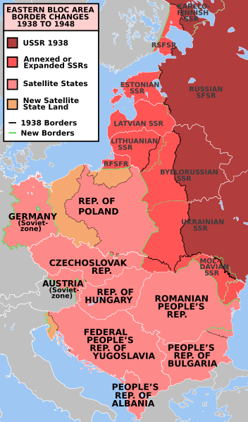
e* Description: Former Eastern Bloc area border changes between 1938 and 1948.
The border and other changes include:
|
||||||||
| Orixe | en.wiki | ||||||||
| Autoría | Mosedschurte | ||||||||
| Licenza (Reuso deste ficheiro) |
|
||||||||
| Outras versións | العربيَّة, Türkçe |

Historial do ficheiro
Prema nunha data/hora para ver o ficheiro tal e como estaba nese momento.
| Data/Hora | Miniatura | Dimensións | Usuario | Comentario | |
|---|---|---|---|---|---|
| actual | 17 de xullo de 2023 ás 22:22 | | 400 × 680 (1,39 MB) | Spesh531 | Corrected 1948-Moldavian SSR lines (white -> green). Thinned out 1948 Estonia & Latvia green lines to match the SSR-SSR border thickness |
| 4 de marzo de 2021 ás 00:42 |  | 400 × 680 (1,38 MB) | Spesh531 | Fixing Czechoslovakia before covered the Austro-Hungarian-Slovak border | |
| 4 de marzo de 2021 ás 00:39 |  | 400 × 680 (1,38 MB) | Spesh531 | I missed Odessa! Which should be the neutral red like Moldova | |
| 3 de marzo de 2021 ás 13:45 |  | 400 × 680 (1,37 MB) | Spesh531 | Hiding internal borders of Yugoslavia and Czechoslovakia | |
| 3 de marzo de 2021 ás 13:40 |  | 400 × 680 (1,33 MB) | Spesh531 | Overhaul of borders. Fixed Julian March. Added Austria occupied zone, Polish-Czech border changes, Austrian/Hungarian/Slovakian tripoint, and better detail in Karelia. | |
| 9 de marzo de 2019 ás 23:33 |  | 396 × 643 (581 kB) | AndreyKva | Optimized. | |
| 9 de xaneiro de 2011 ás 13:07 |  | 396 × 643 (765 kB) | Alokasta~commonswiki | Small changes + I changed east border of Poland: On the old version of this map there was the border after Polish-Soviet territorial exchange in 1951. More info: http://en.wikipedia.org/wiki/1951_Polish–Soviet_territorial_exchange | |
| 9 de xaneiro de 2011 ás 12:41 |  | 396 × 643 (763 kB) | Alokasta~commonswiki | I corrected the polish-german border - in 1938 the Hel Peninsula was the territory of Poland. I changed also the border between Poalnd and Free City of Danzig. I added a white line along the Polish coast. | |
| 16 de setembro de 2009 ás 02:21 |  | 396 × 643 (745 kB) | Stiepan Pietrov | {{Information |Description=e* Description: Former Eastern Bloc area border changes between 1938 and 1948. * Source: Map borders primarily based on [http://commons.wikimedia.org/wiki/File:EC12-1986_European_Community_map.svg] and [http://commons.wikime |
Uso do ficheiro
A seguinte páxina usa este ficheiro:
Uso global do ficheiro
Os seguintes wikis empregan esta imaxe:
- Uso en af.wikipedia.org
- Uso en ar.wikipedia.org
- Uso en azb.wikipedia.org
- Uso en az.wikipedia.org
- Uso en bg.wikipedia.org
- Uso en bn.wikipedia.org
- Uso en ca.wikipedia.org
- Uso en cs.wikipedia.org
- Uso en da.wikipedia.org
- Uso en de.wikipedia.org
- Uso en el.wikipedia.org
- Uso en el.wiktionary.org
- Uso en en.wikipedia.org
- Molotov–Ribbentrop Pact
- World War II
- Eastern Bloc
- History of the United States (1945–1964)
- Cold War
- Origins of the Cold War
- History of the Soviet Union (1927–1953)
- Reinhard Gehlen
- List of national border changes (1914–present)
- Aftermath of World War II
- Military occupations by the Soviet Union
- Key events of the 20th century
- Soviet famine of 1946–1947
- Gehlen Organization
- Political warfare
- User:JacksonKo/ideology
- User:Paul Siebert/sandbox
- User:Falcaorib
- User:Shafin10555/sandbox
- User:Hmmmmm maybe/sandbox
- Cold War (1947–1948)
- Draft:World War II (Draft)
- Uso en en.wikiquote.org
- Uso en eo.wikiquote.org
- Uso en es.wikipedia.org
- Uso en et.wikipedia.org
- Uso en eu.wikipedia.org
- Uso en fa.wikipedia.org
- Uso en fi.wikipedia.org
- Uso en fr.wikipedia.org
- Uso en hif.wikipedia.org
- Uso en hy.wikipedia.org
Ollar o uso global deste ficheiro.