
Ficheiro:East Galicia and Volhynia 1939.png
Non se pode ver nunha resolución meirande.
East_Galicia_and_Volhynia_1939.png (600 × 450 píxeles; tamaño do ficheiro: 74 kB; tipo MIME: image/png)
| Este ficheiro procede de Wikimedia Commons. A continuación móstrase a información da súa páxina de descrición. Commons é un repositorio libre de ficheiros multimedia. Pode contribuír alí cargando as súas imaxes. |
Resumo
| Descrición |
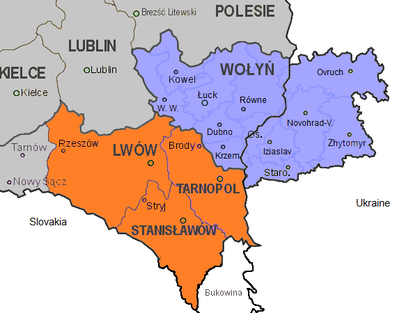
English: Map of the south-eastern part of Poland, within the borders of 1921-1939, as well as the eastern part of Volhynia. Highlighted in orange colour are the three Polish voivodeships of Lwów, Stanisławów, and Tarnopol which form the eastern part of Galicia. Areas in grey are other Polish voivodeships. In blue the Polish voivodeship of Wołyń, with the black border separating the eastern part which was part of the Ukrainian Soviet Socialist Republic. Both parts form the historical region of Volhynia. The internal borders in blue in Volhynia are the old pre-war districts with their capital towns.
Abbreviations of towns in Volhynia: |
| Data | |
| Orixe | Obra propia |
| Autoría | Gryffindor |
| Outras versións |
 |
Licenza
Eu, como posuidor dos dereitos de autor desta obra, pola presente publícoa baixo a seguinte licenza:
| Este ficheiro está dispoñible baixo a licenza Creative Commons de renuncia universal ao dominio público 1.0. | |
| A persoa que asociou unha obra con este documento, deu a obra ao dominio público renunciando a todos os seus dereitos sobre ela en todo o mundo baixo as leis de dereitos de autor e relacionadas ou dereitos legais derivados que tiña sobre a obra, na medida permitida pola lei. Pode copiar, modificar, distribuír e empregar esta obra, mesmo para fins comerciais, sen necesidade dun permiso por parte do autor.
|
| Anotacións | Esta imaxe ten anotacións: Olle as anotacións en Commons |
Historial do ficheiro
Prema nunha data/hora para ver o ficheiro tal e como estaba nese momento.
| Data/Hora | Miniatura | Dimensións | Usuario | Comentario | |
|---|---|---|---|---|---|
| actual | 14 de novembro de 2013 ás 12:20 | | 600 × 450 (74 kB) | Gryffindor | {{Information |Description={{en|Map of the south-eastern part of Poland, within the borders of 1921-1939, as well as the eastern part of Volhynia. Highlighted in orange colour are the three Polish voivodeships of Lwów, Stanisławów, and Tarnopol whic... |
Uso do ficheiro
A seguinte páxina usa este ficheiro:
Uso global do ficheiro
Os seguintes wikis empregan esta imaxe:
- Uso en ca.wikipedia.org
- Uso en cs.wikipedia.org
- Uso en el.wikipedia.org
- Uso en en.wikipedia.org
- Uso en fy.wikipedia.org
- Uso en it.wikipedia.org
- Uso en pl.wikipedia.org
- Uso en sl.wikipedia.org
- Uso en tt.wikipedia.org
- Uso en vi.wikipedia.org